Removing Borders, Erasing Palestinians: Israeli Population Maps after 1967
Despite how it is sometimes represented, the Israeli occupation of Palestine is not the result of some ancient and illogical sectarian quarrel. It instead emerged in concert with international methods of developing and analyzing land, as many Palestinian scholars, and those working with them, have shown. Prior to the Israeli occupation of the West Bank and Gaza Strip in 1967, land management efforts were aimed at clearly defining distinct and separate spaces for Palestinians and Israelis. But this changed after 1967, when the Israeli government began attempts to enforce a single state in both Israel and the Palestinian Territories.
Today, in addition to the devastation of Israeli strikes and incursions, Palestinians are also regularly tried for crossing borders that are functionally invisible and whose precise location, for “security” reasons, they aren’t officially permitted to know. The effects might be comical if they were not so debilitating. To give just one example, despite paying Israeli taxes for decades, Diana Kurd, a Palestinian widow from Anata, was stripped of her pension because her deceased husband had slept on the wrong side of their bed. Namely, his side of the bed lay outside the Jerusalem city boundary, while hers lay within it, yet the boundary itself was determined according to the Israeli authorities’ maps — maps that at such fine scales, are usually classified.
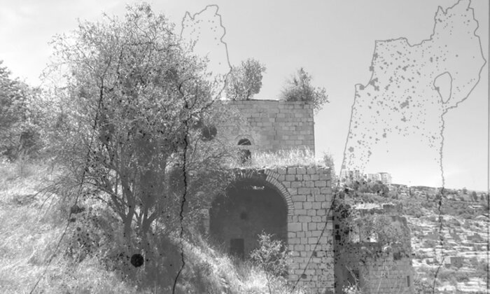
The borders that intrude into the bedroom also split towns in half and sever them from their surrounding regions. The construction of the infamous Wall within the West Bank has created enclaves in Barta’a and western Bethlehem. Despite officially being part of the West Bank, these Palestinian towns are left on the Israeli side of the Wall, which functions as a de facto new border on the ground. The border has literally moved around them. It is as if Canada built a wall around northern Vermont and then told the residents that they were all now illegal squatters on Canadian soil.
Physical inclusion into territory annexed by Israel, however, does not come with citizenship or egalitarian political inclusion in the Israeli state. Instead, the Palestinian inhabitants are trapped. Because of the Wall, they are physically unable to enter the West Bank, but legally they are equally unable to enter Israel even though, for all practical purposes, that is where they now reside. Their presence has become logistically and legally impossible — but partly out of sheer courage and determination, there they are still.
Making these experiments sometimes made me feel like a kindergarten boy playing with colored papers, and afforded boundless amusement for my grandchildren.
—Roberto Bachi, Graphical Rational Patterns
It was decided to carry out the enumeration from house to house under curfew. … The enumerator marked the doors of the houses enumerated with chalk to ensure an orderly and complete coverage.
—(Israeli) Central Bureau of Statistics, West Bank of the Jordan, Gaza Strip, and Northern Sinai, Golan Height
The quotations above, which date from the beginning of the Israeli occupation of the West Bank, serve to illustrate the intimate ties between population control and the development of statistical cartography. The population census described in the second quote began only a little over two months after Jordanian and Israeli troops had ceased fighting street by street through the Old City of Jerusalem. The author of the first quotation, Roberto Bachi, was the head of the Israeli CBS, which was in charge of the enumeration, and he was at the height of his career. Bachi remained a key architect of the Israeli census for over 20 years, and was praised in diverse corners of the international scientific community for his innovative work in statistical cartography and geostatistics.
The quotation captures Bachi’s romantic depiction of his academic research into his method of Graphical Rational Patterns (GRP), which were a new set of symbols for depicting numbers in a precise way on maps. The “colored papers” he refers to were transparent stickers or transfers that were applied when making a map, to prevent the cartographer from having to draw every symbol by hand. The second quotation comes from the official report of the 1967 census of the Palestinian Territories, carried out by the CBS that Bachi both founded and directed. It describes the curfew imposed on the Palestinians, who were forced into their homes, or the home they happened to be closest to at the moment, their doors and walls marked with chalk, so that the count might be considered “orderly and complete.”
There is a clear symbiosis between the colored papers and curfew. In the first instance, Bachi depicts himself cutting into the colored sheets, using glue to stick them into place on maps. In the second, Bachi is at the head of an army of enumerators, supported by the actual military, which physically marches through the streets, metaphorically cutting up groups of people and sending them back inside, fixing them in place, marking them with chalk in order to obtain a clear picture. This confluence of seemingly innocuous snips of paper, on the one hand, and the violence of putting entire regions under house arrest, on the other hand, gives an idea of why the national census, or systematic population count, resonates across such a wide array of research areas. The census encapsulates so many major themes of contemporary social theory: the falsity of the boundary between politics and technoscience; the creep of big data and minute slicing up of individuals and communities into predetermined check boxes like “age” and “nationality.”
The violence of a census under military occupation is not so far distant from the context of the everyday work of national censuses more broadly.
In many countries, the census was one of the main points of interaction between the masses and governments that sought to both discipline and depict them in ways that made sense to bureaucrats. In this context, Bachi’s seeming glibness about his paper cutouts provides a cautionary note for studies of the census that do not take into account the ordinary and extraordinary coercions of quantification. For the violence of a census under military occupation is not so far distant from the context of the everyday work of national censuses more broadly.
Bachi claimed his findings were scientific, and that he concentrated not on political issues but rather on obtaining an objective, quantitative view of Israel and the Palestinian Territories. Yet even Bachi’s most abstruse equations were fully embedded in the cultural and material landscapes where he worked.
The Census as Western Science
Bachi had been a successful professor of statistics in Italy before the fascist government’s racial purity laws forced him to flee prior to World War II. Over the course of his career, Bachi was active either in government, academia, or independent research, throughout nearly every major political transition in the region in the second half of the 20th century, from before the founding of the state of Israel in 1948 until just before the official signing of the second Oslo Accords in 1995. From the beginning, he insisted that the Israeli census be firmly rooted in Western science. The 1948 census was carried out while the war that followed the founding of Israel still raged around them. But even then Bachi contended that the census would be conducted according to rigorous and objective statistical principles. Later, as the director of the Israeli CBS, he continuously argued that military concerns should not be allowed to dominate over scientific rigor.
Throughout this process, he looked to Europe and North America for models for his scientific work. In the planning stages of the Israeli censuses of the 1950s and 1960s, Bachi and his colleagues requested numerous census documents from countries such as Canada, France, and Spain — and coincidentally, from Iran, which at that time was still under the control of the shah, who was politically supported by governments in Europe and North America. Bachi was a main contributor to both the “Statistical Atlas of Italy” and the “Atlas of Israel,” and spoke at innumerable international conferences.
Bachi’s repeated attempts to present his research as objective and neutral are evidenced by the fact that under his leadership, the CBS fought to compile data “solely according to professional considerations, without interference from political quarters,” as the demographers Usiel Schmelz and Nathan Gad write in their book “Studies in the Population of Israel in Honor of Roberto Bachi.” Yet Bachi’s more politicized work counting Palestinians nonetheless exerted a strong influence on his abstract research, and did so in ways that were not wholly incompatible with his aim of developing statistical cartography as a science. As a result, Bachi’s work was both thoroughly scientific and thoroughly colonial at the same time. It therefore demonstrates how empirical science and settler-colonial practices can coincide.
Bachi’s work wasn’t a case of “bad science” but rather a case of how science itself is political, how a violent politics and the scientific goal of rationalization were made to align.
Indeed, Bachi’s academic context was also related to his governmental efforts. In addition to running the census, Bachi founded the Department of Statistics at the Hebrew University of Israel, thereby further linking academic statistics to Israeli state objectives. His two major academic books were published in tandem with census milestones: the first, in 1968, immediately after the census of the Occupied Territories, and the second, after his death in 1995, following the earliest census in Israel to fully incorporate quantitative digital mapmaking of the kind that Bachi had long advocated. Both books, which I examine in detail in “Mapping Israel, Mapping Palestine,” address key issues of the census and develop methodologies first implemented in the enumeration of the Occupied Palestinian Territories (OPT). As such, the theoretical, academic, and governmental areas of Bachi’s professional career were thoroughly interlinked, and mutually reinforced one another.
The relationship between Bachi’s governmental and theoretical work was also affected by the advent of digital cartographic technology. Throughout his career, Bachi took part in a technological transition in cartography from a professionalized trade that relied on hand-drafting skills into a quantified, mechanized science that became heavily dependent on computers. Bachi himself was trained within a modernist tradition of statistical cartography in Italy. He was instrumental in bringing the paradigm to the nascent Israeli state, where it was further developed in part due to his personal efforts. Additionally, later methods enabled the detailed management of piecemeal territories — a type of complexity that is considered a hallmark of postmodern or late modern digital governance.
Computers are often presented as a break or revolution in the history of technology, an abrupt disjuncture between the modern and postmodern. However, Bachi’s maps serve to demonstrate that this is not an all-or-nothing transition. Bachi’s work wasn’t a case of “bad science” but rather a case of how science itself is political, how a violent politics and the scientific goal of rationalization were made to align. Bachi chose to further key modernist goals in formulating cartographic knowledge, such as accuracy and the continuity of borders, and this lent continuity to the maps he made both before and after computers became commonplace. He also actively rejected other goals considered to be hallmarks of modern statistics, like completeness and the consistency of space. So his later studies arguably are evidence of a new form of modernism that challenged the fundamental goals of completeness and consistency, but nevertheless it is one that still would be accepted and recognized among international scientific communities.
Moreover, Bachi’s research illustrates how in the context of modernization processes, the landscapes that are produced can transform the goals of modernization. The efforts to enforce a single set of national borders for Israel instead spiraled into the construction of tightly linked networks of bounded settlements in the West Bank. In time, the very process of determining their borders would transform the aims and purpose of Bachi’s theoretical work. Bachi largely cooperated with broader efforts to literally and figuratively expunge Palestinians from the land. Yet he could not extricate himself from the social and material connections afforded by his physical proximity to Palestinian communities. As a result, years of occupation ultimately fed back into his statistical cartography, shaping both Bachi’s research trajectory and, through him, the very fabric of the digital canvas on which population statistics in the region continue to be mapped.
Palestinian Existence and the Israeli Census
The outcome of a conflict between two parties usually doesn’t hinge on a debate over whether or not one of them exists. But this is precisely the way that some Zionist groups have attempted to frame debates over the right of Palestinians to live in and enter Israel and the Occupied Territories. Prime Minister Golda Meir’s famous proclamation in 1969 that, “There never was such a thing as Palestinians. … They did not exist” has been reiterated over countless election cycles both within Israel and abroad.
Irrespective of these claims to Palestinian nonexistence, from the perspective of the Israeli military administrators who took over the Palestinian Territories in 1967, the Palestinians existed and needed to be counted. The first steps were to devise population categories, count people according to them, and note the precise locations of every individual. This is precisely what the CBS set out to do. But the population count was not only aimed at the surveillance of those in the OPT. If the push to conduct a census after the 1967 war demonstrates a tacit acknowledgment of Palestinians’ existence, the census also aimed to limit the number of Palestinians who were allowed to remain. As Anat Leibler, a researcher who specializes in the study of quantification, has shown, one of the primary motivations for conducting the census so quickly was to prevent those who had fled during the conflict from returning. The census was the basis for issuing identity cards that allowed their bearers to reside permanently in the Palestinian Territories, if not to become citizens. So by performing the census early, the administrators prevented those who were away from gaining the right to come back.
One of the primary motivations for conducting the census so quickly was to prevent those who had fled during the conflict from returning.
As a result, the census could be said to have two potentially conflicting priorities: on the one hand, to gain an accurate count of the populations now under Israeli control; on the other hand, to exclude as many people as possible in order for fewer Palestinians to be able to claim residency. Since the population of Israel was produced in part through the census, it was crucial for census takers to preemptively make as many Palestinians as possible uncountable, and therefore invisible and, for national purposes, nonexistent. It was, in other words, in the best interest of the census takers both to rigorously count Palestinians who were there and shape the population by excluding Palestinians before anyone was ever counted.
In this context, the census authorities were especially wary of being charged with undercounting. They consequently stress the extreme lengths to which census enumerators went to obtain precise enumerations. Their report notes that “despite the use of special vehicles (and even donkeys), the enumerators could not reach isolated houses or distant localities (especially nomads’ tents), because of difficulties of access or danger of mines.” In so doing, they highlight some of the ways that as a result of enduring political realities, much of the West Bank became practically inaccessible to the Israelis in the immediate aftermath of the war. So just as the very presence of Palestinians made the 1967 counting necessary, in the eyes of Israeli officials, the ongoing geographic impacts of 1948 and 1967 circumscribed their ability to conduct that census. The census in turn would affect the types of maps that Bachi used and advocated in his 1968 book, “Graphical Rational Patterns: A New Approach to Graphical Presentation of Statistics.” His theoretical academic work is thus emblematic of the census maps that had tremendous practical power over Palestinians’ lives.
Bachi played a key role in the way the 1967 census was conducted, and his name appears on the official report both as the “director of the census” and “government statistician.” In the process, however, he contradicted one of his own judgments from 1948. Back then, against members of the Israeli military who had wanted to count Palestinians with different methods from those used by Israelis, Bachi argued forcefully that the methodology should remain the same for both groups. He claimed that only with consistent methods would the results be seen to be statistically rigorous. The 1948 census reports also described the hesitancy to enumerate Jews via a curfew, given that this method had been widely used by the British during their occupation after World War I, and thereby would have brought back traumatic memories. Yet by 1967, under Bachi’s direction, the census did precisely this for Palestinians — a process undertaken for the OPT alone. So a curfew that was seen as too debilitating for Israeli citizens was nonetheless applied to Palestinians in the West Bank and Gaza Strip. Bachi oversaw the one-day curfew with the stated reasoning that indiscriminately confining people to their homes would improve the chances of counting as many people as possible.
The curfew was justified using arguments for accuracy, but it had its own consequences in terms of the accuracy of the statistics. The curfew indeed excluded refugees who were missing, away from home, or homeless due to the war. It also, by the census takers’ own omission, had the effect of creating “differences between the locality in which [inhabitants] were registered and the permanent places of residence.” People were counted according to where they happened to be under the curfew, not necessarily where they primarily lived.
A curfew that was seen as too debilitating for Israeli citizens was nonetheless applied to Palestinians in the West Bank and Gaza Strip.
The resulting census data for the Palestinian Territories would have presented a logical conundrum for Bachi. As someone who considered himself a scientist, to Bachi the Palestinian census data would have seemed less than rigorous — seeing as how they were collected under restrictive conditions that made them only partially comparable to census data for the fully annexed areas of the state of Israel. Yet also as a scientist, he could not completely ignore that the data existed — for example, by placing labels that read “no data available” on relevant areas of his maps of Israel. After all, he spearheaded the operation that collected the data in the first place. So on scientific maps, the question for Bachi would have become: How is it possible to best map Israel while neither denying that data exist for Palestinians, nor actually including that (only semirigorous) census data on the map?
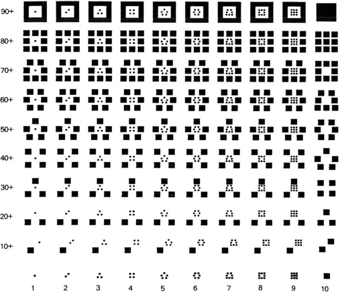
In fact, despite directing and overseeing the census of the OPT, Bachi rarely, if ever, used the data from that census in his work. To omit the data without appearing to be unscientific, Bachi increasingly began using one type of map from among two commonly available options. As is evident in his 1968 book, for mapping census data collected from 1967 onward, Bachi started to favor graduated circles more and more. He became increasingly critical of the shaded area technique called choropleth, which was more commonly used at the time. Choropleths are maps in which districts, states, or regions are progressively shaded darker or lighter in order to represent increased percentages of some particular characteristic, such as the average number of people in each household for specific areas. Choropleths are convenient because unlike graduated circle maps, they allow cartographers to indicate statistical data without an abundance of different symbols. At the same time, they can be misleading, and there are several problems that arise. For instance, because different regions are shaded in, those with larger geographic areas often stand out as more significant than they would otherwise appear to be, if they were judged by the statistics alone — and this is only one of multiple layers of complexity.
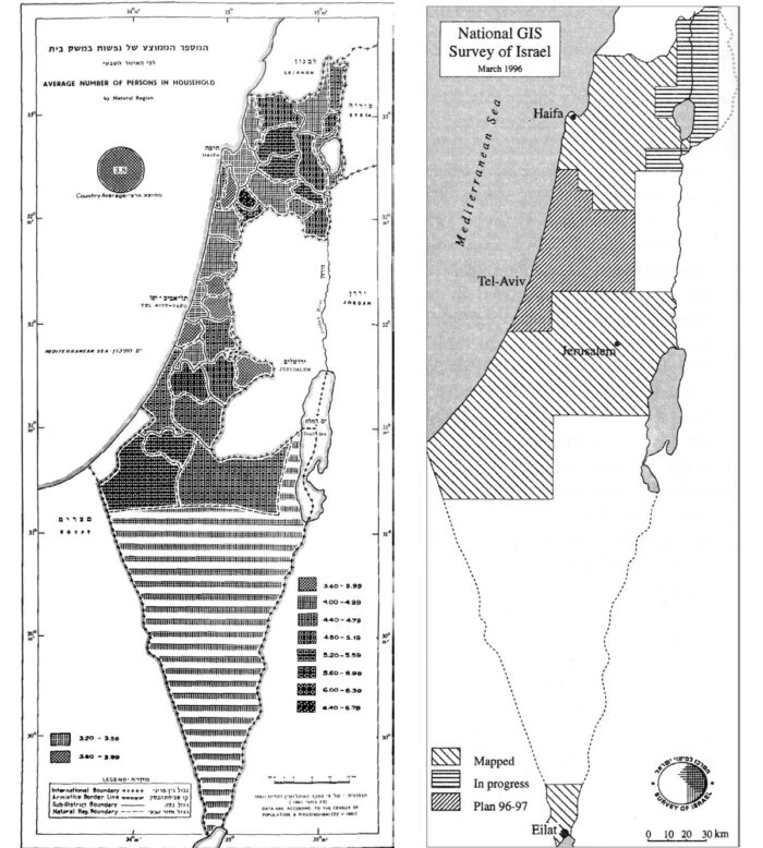
In contrast to choropleths, graduated circle maps are those that use shapes of different sizes, generally circles, to represent a particular statistic. The difference between choropleths and graduated circles are not obvious at first, and both are widely used. But graduated circle maps have one advantage that relates to Bachi’s research: They allow for the omission of certain boundaries, including the Green Line, which was used to delineate the demarcation line between Israel, Jordan, Egypt and Syria from the period following Israel’s 1948 Independence War until Israel captured the West Bank in 1967. For instead of shading an entire area or subregion, the graduated circle is located with respect to one single point on the map.
This allows for greater precision in depicting — or choosing arbitrarily, since a random point could be used — the precise locations of populations within national boundaries. The result, however, is that in graduated circle maps, the actual boundaries of those districts do not have to be included on the map. In contrast, on choropleths, if each district is shaded in, then the edges of those shaded regions — their boundaries — are already implicitly indicated. This had its limits, however, as on some maps that omit the borders around the West Bank and Gaza strip, a ghost of the political border can be seen around segregated Palestinian areas. By depicted these as blank areas, Bachi in effect sketched out the boundary as a type of palimpsest. There were simply so many Palestinians, and the Israeli military had pushed them into segregated areas like the West Bank, that the Palestinians show up through their very erasure.
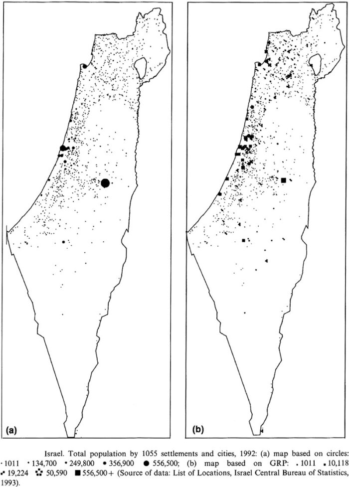
Bachi’s 1968 book is evidence of how, in his early work, he started omitting internal boundaries and moving from areas to points. In contrast, by 1995, Bachi had largely abandoned his attempts to rectify GRPs with choropleth maps. He turned instead to drawing boundaries around statistical data, beginning to constitute new borders based only on those points that he selected as being significant to the census. In so doing, Bachi again adapted and innovated on international statistics in order to meet the strategic political goals of the Israeli state. In the process, he rejected the traditional focus on the consistency of national territory in order to retain the continuity of borders around the fragmented territories, including the settlements, claimed by the state. His methods allowed for an enlargement of the total area of Israel that is inhabited by Israelis, and they did so in a way that naturalizes the settlements as a part of Israel.
In addition, when the total area of a particular settlement is determined based on the furthest points of habitation, these can be far larger than its official municipal boundaries, which might take longer to catch up to the pace of construction. Any private Palestinian areas that happened to fall between two outlying points would simply be incorporated into Israeli territory through the use of the convex hull — that is, by drawing an enclosed line around those (newly) Israeli points and calling everything in between “Israeli.” In combination with GIS software, the geographic database that was developed in the course of the 1995 census enabled the cartographers to calculate convex hulls for hundreds of thousands of individual points at ever finer scales, including individual buildings, thereby defining and quantifying a set of ever more multiplicitous borders. The convex hull method sacrificed national contiguity in order to maintain strict and increasingly numerous boundaries. Yet the fact that there were more borders did not mean that they became more open or less guarded; quite the contrary.
The Continuity of Computer Cartography
Population statistics, like those developed in the national census, form one of the core connections between the state and local communities, and they are central to everyday governance practices. As one of the primary means through which population statistics are communicated, census cartography fundamentally influences both national and international public imaginations of those governance practices as well as society itself. Yet cartographic methods are also shaped in local social and geographical landscapes. Bachi’s attempts to make graphing and statistical mapmaking more readily available served to place him in the international statistical vanguard, but his work continued to be informed by the political realities of the Israeli occupation.
This was not obviated by the spread of computers and their allegedly universal rationality. In the end, instead of representing a radical departure from previous cartographic methods, computers and GIS proved useful in legitimizing Bachi’s political position and further integrating it into the international scientific community. While the public use of his GRP symbols was fast outpaced by computer graphics capabilities — even to the extent that they appear less frequently in Bachi’s own later research — his contributions to core concerns of geographic and demographic statistics, and their application in statistical cartography, continue to be influential, as many researchers have demonstrated.
By omitting internal boundaries altogether, Bachi could include Israeli data without making plain that such data for the Palestinian Territories were either not being collected or, in the case of the census, not being indicated on the map.
By omitting internal boundaries altogether, Bachi could include Israeli data without making plain that such data for the Palestinian Territories were either not being collected or, in the case of the census, not being indicated on the map. He then helped to actively naturalize the presence of Israeli settlements in the landscape by redrawing boundaries around the area of Jewish habitation — an area that by design, were spread across most of the Palestinian Territories. As such, both GRPs and convex hulls were useful in constructing facts that were empirical and political. Yet in order to reconstruct a total national area that includes the settlements, the 1995 census first had to extricate the settlements from their surroundings — that is, precisely the numerous Palestinian towns of the West Bank and Gaza Strip.
Bachi’s research is therefore both fully internationally scientific and thoroughly influenced by local political contexts. Despite his best efforts to position himself otherwise, Bachi’s work even at the most abstract levels was shaped by the landscape of Palestine and Israel. At the same time, his choices were circumscribed by the hierarchies of international technoscience — whereby his legitimacy depended on his ability to present his findings as objective and exact. Computers lent credence to this goal. But the tension between maintaining supposed empirical rigor, on the one hand, and adapting his methodology to the people and landscapes so that they might further the simultaneous oppression and erasure of Palestinians by the Israeli government, on the other hand, is one that continued through the adoption of GIS in the region. Rather than furthering goals of equality and justice, GIS was mobilized to rationalize Israeli state violence against Palestinians that sadly continues to this day.
Jess Bier is an assistant professor of urban sociology at Erasmus University Rotterdam, where she studies the social and political landscapes of science and technology. She is the author of “Mapping Israel, Mapping Palestine: How Occupied Landscapes Shape Scientific Knowledge,” from which this article is adapted.